![Garmin Navionics+ NSSA004L - Mexico, the Caribbean to Brazil - Inland Coastal Marine Chart [010-C1285-20]](http://petersonmarineinc.com/cdn/shop/files/96095XL_1200x.jpg?v=1711083852)
- Choosing a selection results in a full page refresh.
![Garmin Navionics+ NSSA004L - Mexico, the Caribbean to Brazil - Inland Coastal Marine Chart [010-C1285-20]](http://petersonmarineinc.com/cdn/shop/files/96095XL_medium.jpg?v=1711083852)
Couldn't load pickup availability
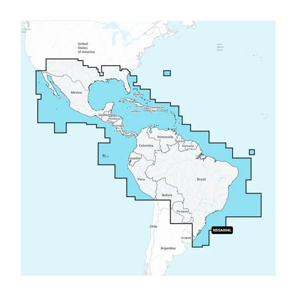
Navionics+™ NSSA004L - Mexico, the Caribbean to Brazil - Inland & Coastal Marine Chart
Get the world’s No. 1 choice in the marine mapping with the best, most up-to-date Navionics®+ cartography on your compatible chartplotter.
Featuring vibrant colors, a streamlined interface and combined coastal/inland content with a popular Navionics® style color palette, Garmin Navionics+ cartography makes it easy to plot your course. Multiple shading options aid in shallow water navigation and make it easy to highlight a target depth range for the best fishing spots. Fully customizable with various chart layers, overlay combinations and up to 10 color-shaded target depth ranges to scope out the best fishing spots.
When you purchase a new Garmin Navionics+ or Garmin Navionics Vision+ cartography product, a one-year subscription is included.
Chart Code - NSSA004L
Coverage Area:
Coastal coverage of Mexico, Central America and Brazil. Coverage includes the US Gulf Coast and the eastern US coast to Savannah, GA; Bermuda; the Bahamas; Cuba; Hispaniola; Puerto Rico and the Virgin Islands; the Windward and Leeward Islands; Jamaica; the Panama Canal, the western coast of South America to Arica, Chile; the Galapagos Islands; the Revillagigedo Islands; the Ilha Fernando de Noronha; the Saint Peter and Saint Paul Archipelago and the Rocas Atoll.
Features:
Compatibility:
Technical Specifications:
In the Box:
1Auto Guidance+ is for planning purposes only and does not replace safe navigation operations
*Sold as an Individual
Thanks for subscribing!
This email has been registered!
| Product | SKU | Description | Collection | Availability | Product Type | Other Details |
|---|
![Lowrance Eagle Power Cord f/Eagle 5/7/9 Eagle Eye 9 [000-16314-001]](http://petersonmarineinc.com/cdn/shop/files/104570XL_940x.jpg?v=1726498756)
![Victron Lynx Shunt VE.Can (M10) [LYN040102110]](http://petersonmarineinc.com/cdn/shop/files/103441XL_940x.jpg?v=1722291582)
![Victron Lynx Shunt VE.Can (M10) [LYN040102110]](http://petersonmarineinc.com/cdn/shop/files/103441BXL_940x.jpg?v=1722291584)
![Marinco 12V Chrome Plated Single Trumpet Mini Air Horn [10107]](http://petersonmarineinc.com/cdn/shop/files/79167XL_940x.jpg?v=1711009694)
![Garmin Bail Mount w/Knobs f/echoMAP CHIRP 7xsv 9xsv [010-12445-32]](http://petersonmarineinc.com/cdn/shop/files/58972XL_940x.jpg?v=1710946703)
![Navico Ethernet Adapter M12 8-Pin Male - Yellow 5-Pin Female - 1.2' [000-16448-001]](http://petersonmarineinc.com/cdn/shop/files/109884XL_940x.jpg?v=1756858788)
![Victron GX-IO Extender 150 [BPP900800150]](http://petersonmarineinc.com/cdn/shop/files/109226XL_940x.jpg?v=1750875384)
![Victron GX-IO Extender 150 [BPP900800150]](http://petersonmarineinc.com/cdn/shop/files/109226BXL_940x.jpg?v=1750875385)
![Dometic 975 Portable Toilet w/Mounting Brackets - 5 Gallon - Grey [301097506]](http://petersonmarineinc.com/cdn/shop/files/37728XL_940x.jpg?v=1730238154)
![Garmin ECHOMAP UHD2 63sv Chartplotter/Fishfinder Combo w/US Inland Maps GT54UHD-TM [010-02680-01]](http://petersonmarineinc.com/cdn/shop/files/98032XL_940x.jpg?v=1724257064)
![Garmin ECHOMAP UHD2 63sv Chartplotter/Fishfinder Combo w/US Inland Maps GT54UHD-TM [010-02680-01]](http://petersonmarineinc.com/cdn/shop/files/98032BXL_940x.jpg?v=1724257066)